Category: Weather Center Update

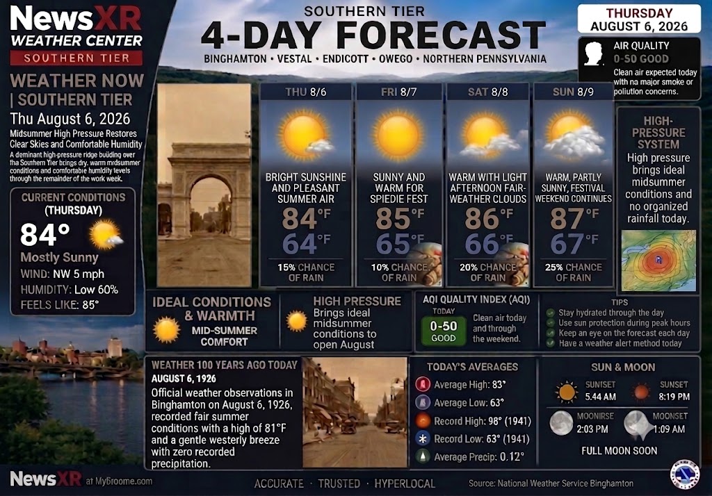
  • WEATHER NOW – Thursday, August 6, 2026

    WEATHER NOW – Thursday, August 6, 2026

    WEATHER NOW from NewsXR

    Warm August Air Builds Over the Southern Tier, With Afternoon Storm Chances Becoming the Main Thing to Watch

    The Southern Tier is heading into a warm and humid stretch as August settles in over Broome County, but the forecast is no longer as quiet as the earlier outlook suggested. While temperatures remain seasonable to warm through the next several days, the main concern will be the daily chance for showers and thunderstorms, especially during the afternoon and evening hours. For Binghamton, the latest forecast shows showers and a thunderstorm possible later Thursday, drenching thunderstorms possible Friday afternoon, and another afternoon thunderstorm chance on Saturday.

    For Binghamton and surrounding communities, Thursday brings a mix of clouds and sunshine with the temperature climbing into the low 80s. The day starts manageable, but humidity increases the midsummer feel, and a couple of showers or a thunderstorm may develop later in the day. Any storm that forms could briefly produce heavier downpours, gusty wind, and quick changes in road conditions, so residents with evening plans should keep an eye on radar before heading out.

    Weather Update Alert: NewsXR is updating the earlier Weather Now outlook after the forecast shifted toward a more humid pattern with afternoon shower and thunderstorm chances through Spiedie Fest weekend. This is not an official weather warning, but residents and festivalgoers should stay weather-aware and check conditions before heading out.

    Friday, August 7, brings another warm and humid day as Spiedie Fest weekend begins at Otsiningo Park. Conditions do not look like a washout, but festivalgoers should plan for variable clouds and the possibility of afternoon drenching thunderstorms. The best advice for opening-day events is simple: dress for humidity, bring water, use sun protection when the sun breaks through, and have a quick shelter plan if thunder is heard. Friday’s high is expected to reach the lower 80s, with overnight lows staying mild in the upper 60s.

    Saturday continues the warm pattern, with clouds, breaks of sun, and another chance for an afternoon thunderstorm. That means outdoor plans across Broome County should remain workable, but not completely weather-proof. Balloon launches, park events, youth sports, walking routes, and backyard gatherings may all depend on timing. As usual in August, one neighborhood may stay dry while another sees a brief downpour, so the practical forecast is not “cancel everything,” but “stay weather-aware.”

    Sunday looks a little less humid, though clouds may still outnumber sunshine at times. Temperatures remain near the low 80s, giving the region another warm festival day, but with a somewhat more comfortable feel compared with the stickier air expected Thursday through Saturday.

    Today’s Forecast – Thursday, August 6

    Binghamton and the surrounding Southern Tier can expect clouds and sunshine, humid air, and a couple of showers or thunderstorms mainly later in the day. High near 82°F. Low near 66°F.

    Friday, August 7

    Humid with variable clouds and a chance for a couple of drenching afternoon thunderstorms. High near 81°F. Low near 67°F.

    Saturday, August 8

    Humid with clouds and breaks of sun, with a thunderstorm possible during the afternoon. High near 83°F. Low near 65°F.

    Sunday, August 9

    Less humid with more clouds than sun. High near 81°F. Low near 65°F.

    Spiedie Fest Weather Watch

    With Spiedie Fest opening Friday and continuing through the weekend, the weather story is timing. The warm air supports a summer festival feel, but the humidity and storm chances mean visitors should check the latest forecast before leaving home, keep phones charged for alerts, and be ready to pause outdoor activity if thunder approaches. Hot air balloon launches are especially sensitive to wind, rain, and storm development, so launch decisions may vary by conditions at the park.

    Weather Safety Reminder

    Afternoon storms can build quickly in August. If thunder is heard, move indoors or into a hard-topped vehicle. Avoid open fields, tall isolated trees, water, metal fencing, and exposed park areas until the storm has passed. Drivers should use extra caution during sudden downpours, especially on highways, shaded roads, and low-lying spots where water can collect quickly.

    Weather 100 Years Ago Today

    On August 6, 1926, official weather observations in Binghamton recorded fair summer conditions, a high of 81°F, a gentle westerly breeze, and no recorded precipitation. A century later, the temperatures remain familiar for early August, but today’s weather story is more unsettled, with humidity and afternoon storm chances shaping the local forecast.
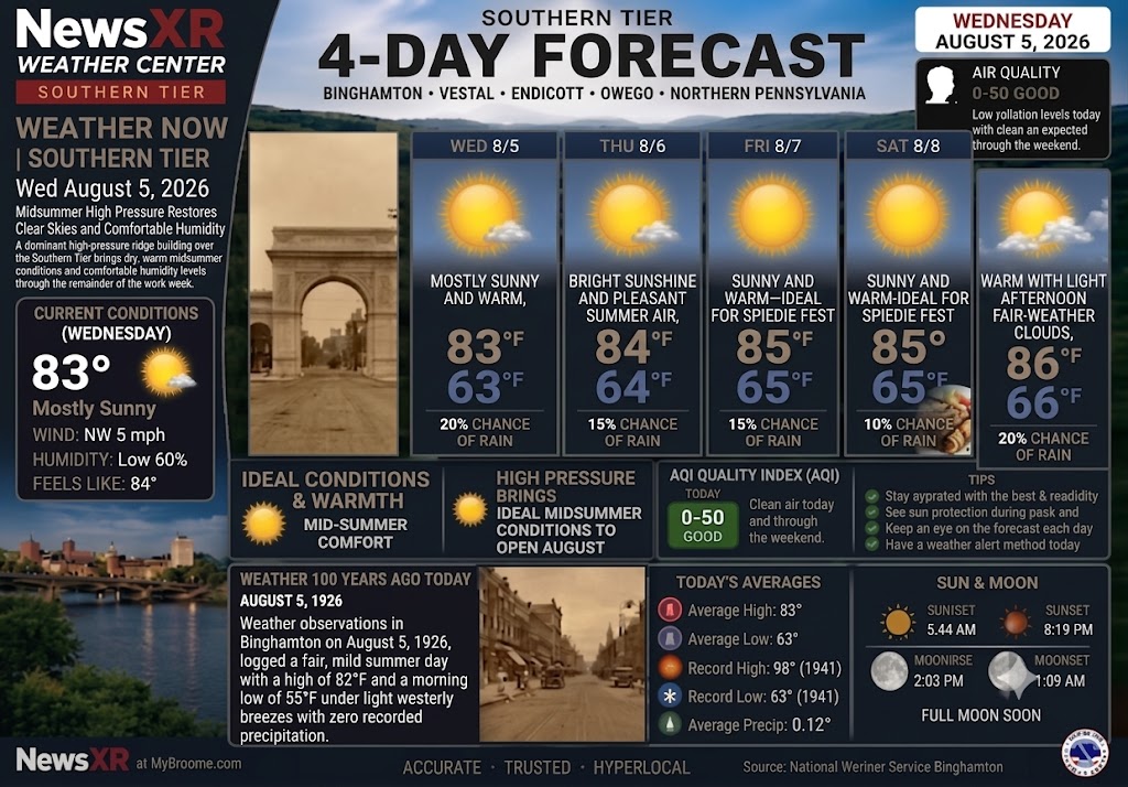
  • WEATHER NOW – Wednesday, August 5, 2026

    WEATHER NOW – Wednesday, August 5, 2026

    WEATHER NOW from NewsXR

    Midsummer High Pressure Restores Clear Skies and Comfortable Humidity A dominant high-pressure ridge building over the Southern Tier brings dry, warm midsummer conditions and comfortable humidity levels through the remainder of the work week.

    Today (Wednesday, August 5): Mostly sunny and warm, high 83°F / low 63°F, 20% rain chance.

    Thursday (August 6): Bright sunshine and pleasant summer air, high 84°F / low 64°F, 15% rain chance.

    Friday (August 7): Sunny and warm—ideal weather for Spiedie Fest opening events at Otsiningo Park, high 85°F / low 65°F, 10% rain chance.

    Saturday (August 8): Warm with light afternoon fair-weather clouds, high 86°F / low 66°F, 20% rain chance.

    Weather 100 Years Ago Today (August 5, 1926) Weather observations in Binghamton on August 5, 1926, logged a fair, mild summer day with a high of 82°F and a morning low of 55°F under light westerly breezes with zero recorded precipitation.

  • WEATHER NOW – Tuesday, August 4, 2026

    WEATHER NOW – Tuesday, August 4, 2026

    WEATHER NOW from NewsXR

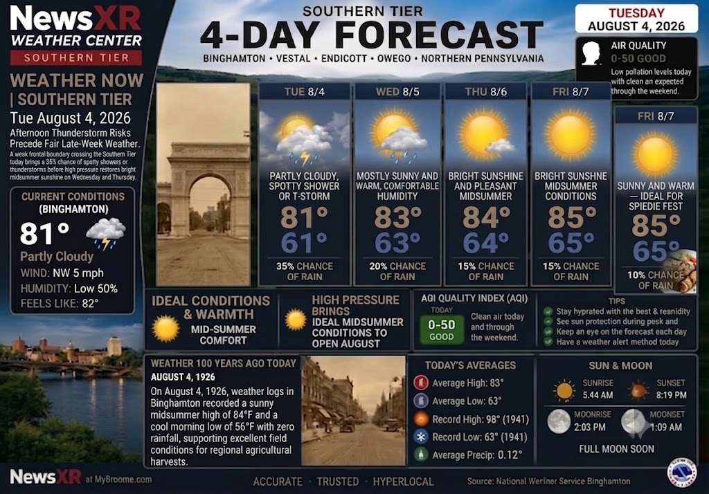
    Afternoon Thunderstorm Risks Precede Fair Late-Week Weather

    A weak frontal boundary crossing the Southern Tier today brings a 35% chance of spotty afternoon showers or localized thunderstorms before high pressure restores bright midsummer sunshine on Wednesday and Thursday.

    • Today (Tuesday, August 4): Partly cloudy with spotty afternoon showers or thunderstorms possible, high 81°F / low 61°F, 35% rain chance.

    • Wednesday (August 5): Mostly sunny and warm with comfortable humidity, high 83°F / low 63°F, 20% rain chance.

    • Thursday (August 6): Bright sunshine and pleasant midsummer conditions, high 84°F / low 64°F, 15% rain chance.

    • Friday (August 7): Sunny and warm—ideal for Spiedie Fest opening events, high 85°F / low 65°F, 10% rain chance.

    Weather 100 Years Ago Today (August 4, 1926)

    On August 4, 1926, weather logs in Binghamton recorded a sunny midsummer high of 84°F and a cool morning low of 56°F with zero rainfall, supporting excellent field conditions for regional agricultural harvests.

  • WEATHER NOW – Monday, August 3, 2026

    WEATHER NOW – Monday, August 3, 2026

    WEATHER NOW from NewsXR

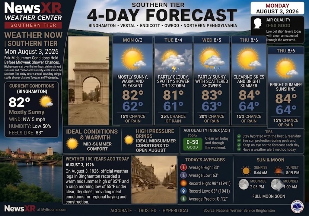
    Fair Midsummer Conditions Hold Before Midweek Shower Chances

    High-pressure air over the Northeast delivers bright sunshine and comfortable humidity levels across the Southern Tier today before a weak boundary brings spotty shower chances Tuesday and Wednesday.

    • Today (Monday, August 3): Mostly sunny, warm, and pleasant, high 82°F / low 62°F, 15% rain chance.

    • Tuesday (August 4): Partly cloudy with a spotty afternoon shower or thunderstorm possible, high 81°F / low 61°F, 35% rain chance.

    • Wednesday (August 5): Partly sunny with scattered afternoon showers, high 83°F / low 63°F, 30% rain chance.

    • Thursday (August 6): Clearing skies and bright summer sunshine, high 84°F / low 64°F, 15% rain chance.

    Weather 100 Years Ago Today (August 3, 1926)

    On August 3, 1926, official weather logs in Binghamton recorded a warm midsummer high of 85°F and a crisp morning low of 55°F under clear, dry skies, providing ideal conditions for regional haying and construction.

    © 2026 CompanyXR Media Group – All Rights Reserved | MyBroome.com™ | NewsXR.org

  • WEATHER NOW – August 2, 2026

    WEATHER NOW – August 2, 2026

    WEATHER NOW from NewsXR

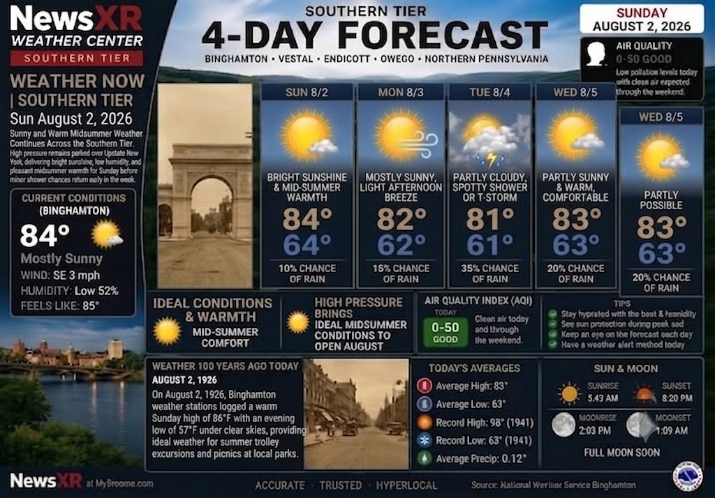
    Sunny and Warm Midsummer Weather Continues Across the Southern Tier

    High pressure remains parked over Upstate New York, delivering bright sunshine, low humidity, and pleasant midsummer warmth for Sunday before minor shower chances return early in the week.

    • Today (Sunday, August 2): Bright sunshine and pleasant midsummer warmth, high 84°F / low 64°F, 10% rain chance.

    • Monday (August 3): Mostly sunny with a light afternoon breeze, high 82°F / low 62°F, 15% rain chance.

    • Tuesday (August 4): Partly cloudy with a spotty afternoon shower or thunderstorm possible, high 81°F / low 61°F, 35% rain chance.

    • Wednesday (August 5): Partly sunny and warm with comfortable summer temperatures, high 83°F / low 63°F, 20% rain chance.

    Weather 100 Years Ago Today (August 2, 1926)

    On August 2, 1926, Binghamton weather stations logged a warm Sunday high of 86°F with an evening low of 57°F under clear skies, providing ideal weather for summer trolley excursions and picnics at local parks.

  • NewsXR Weather Now: August 1, 2026

    NewsXR Weather Now: August 1, 2026

    ☀️ Hello Southern Tier! Say goodbye to the rain! High pressure is moving in, bringing us beautiful, comfortable midsummer weather for the start of August. Here’s your ‘NewsXR Weather Now’ update for Saturday, August 1, 2026:

    Today: Expect bright sunshine, warm (but not humid) temperatures, and seasonable highs.Forecast Highlights:

    • 🌡️ Highs in the low 80s through Tuesday.

    • 🌌 Cool nights with lows in the low 60s.

    • 💧 Very low rain chances (10-15%) for the weekend and Monday.

    • ☁️ A slight increase in clouds and a small chance (30%) of a spotty shower by Tuesday.

    Check the attached graphic for the full 4-day breakdown, the current Air Quality Index, and a look back at the weather on this date 100 years ago in 1926!

  • WEATHER CENTER REPORT: WEDNESDAY, JULY 29, 2026

    WEATHER CENTER REPORT: WEDNESDAY, JULY 29, 2026

    🌤️ WEATHER REPORT: WEDNESDAY, JULY 29, 2026

    From the NewsXR Weather Center at MyBroome.com

    Accurate • Trusted • Hyperlocal

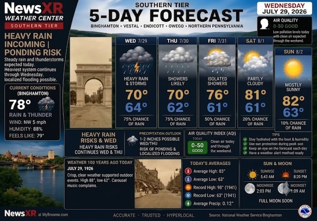
    🌩️ HEAVY RAIN & PONDING RISK ACROSS BROOME COUNTY

    A slow-moving atmospheric system is keeping Broome County and the Southern Tier under active weather alerts today. Ground conditions across the region remain highly saturated from recent rainfall, elevating the risk for localized flash flooding, standing water, and road ponding throughout Binghamton, Vestal, Endicott, Owego, and Northern Pennsylvania.

    Persistent rain bands and embedded thunderstorms will continue tracking through the area through Wednesday evening, with heavy downpours capable of dropping an additional 1 to 2 inches of rainfall in localized spots.

    📊 TODAY’S DETAILED BREAKDOWN (WEDNESDAY, JULY 29)

    • Current Conditions (Binghamton): 78°F with active rain and thunder. Winds are light out of the Northwest at 5 mph with humidity sitting at 88% (Feels like 79°F).

    • High / Low Temperature: High of 70°F | Low of 64°F

    • Precipitation Chance: 75% with heavy rain and active thunderstorms expected throughout the afternoon and evening.

    • Impact & Hazards: Moderate to high risk of localized street ponding and minor stream flooding in low-lying drainage basins. Drive with caution during peak commuting hours.

    • Air Quality Index (AQI): 0–50 (GOOD) — Low pollution levels expected to remain clean through the weekend.

    • Sun & Moon: Sunrise at 5:43 AM | Sunset at 8:20 PM | Moonrise at 2:03 PM | Moonset at 1:09 AM (Full Moon approaching).

    🗓️ 5-DAY EXTENDED OUTLOOK

    • Thursday (July 30): Showers remain likely as the system slowly exits. High 70°F / Low 62°F (75% chance of rain).

    • Friday (July 31): Turning noticeably brighter with passing isolated showers tapering off late. High 76°F / Low 61°F (50% chance of rain).

    • Saturday (August 1): Pleasant conditions return to start the weekend! Partly cloudy and warmer. High 81°F / Low 61°F (20% chance of rain).

    • Sunday (August 2): Mostly sunny, dry, and ideal for outdoor activities. High 82°F / Low 63°F (10% chance of rain).

    📜 WEATHER 100 YEARS AGO TODAY (JULY 29, 1926)

    A century ago today, Broome County experienced crisp, clear summer weather that supported outdoor gatherings and community events across the Triple Cities. High temperatures reached 88°F with an evening low of 62°F—a stark contrast to today’s heavy downpours! Local archives even recorded lighthearted citizen complaints regarding “jazzy carousel music” carrying across open windows into the evening hours.

    • Record High for July 29: 98°F (1941)

    • Record Low for July 29: 63°F (1941)

    • Historical Average Precip: 0.12″

    © 2026 CompanyXR Media Group – All Rights Reserved | MyBroome.com

  • WEATHER NOW: Southern Tier 5-Day Weather Forecast

    WEATHER NOW: Southern Tier 5-Day Weather Forecast

    WEATHER NOW: Southern Tier 5-Day Weather Forecast

    (July 28, 2026)

    BINGHAMTON, N.Y. — Heavy rain and lingering thunderstorms dominate today’s weather across Broome County and the broader Southern Tier. Steady rain and active systems are expected today, with the heaviest continuation through Wednesday, creating a risk of localized road flooding and stream ponding.

    Current Conditions (Binghamton)

    • Temperature: 78°F (Feels like 79°F)

    • Conditions: Rain & Thunder

    • Wind: NW at 5 mph

    • Humidity: 88%

    NewsXR Southern Tier 5-Day Outlook

    • Tuesday, July 28: Heavy rain & storms. Risk of road ponding and localized flooding. High 70° | Low 64° (75% chance of rain)

    • Wednesday, July 29: Rain and showers continuing. High 70° | Low 62° (75% chance of rain)

    • Thursday, July 30: Light rain possible with high clouds. High 76° | Low 61° (75% chance of rain)

    • Friday, July 31: Passing showers. High 81° | Low 61° (40% chance of rain)

    • Saturday, August 1: Pleasant & sunny conditions return. High 82° | Low 63° (10% chance of rain)

    Precipitation & Air Quality

    • Precipitation Outlook: 2–3 inches possible Tuesday and Wednesday. Risk of ponding and localized flooding.

    • Air Quality Index (AQI): 0–50 (GOOD) — Clean air today and through the weekend.

    • Sun & Moon: Sunrise 5:42 AM | Sunset 8:21 PM (Moonrise 2:03 PM | Moonset 1:09 AM — Full Moon Soon).

    Weather 100 Years Ago Today (July 28, 1926)

    Binghamton on July 28, 1926, was equally impactful. The high reached 88 degrees, and the region was blanketed by an unusually dense, muggy atmosphere, with humidity near 90%. Crisp, clear weather supported outdoor events like the Endicott hospital cornerstone ceremony. Open windows led to now-famous complaints about “jazzy” carousel music.

  • WEATHER NOW: Southern Tier 5-Day Forecast

    WEATHER NOW: Southern Tier 5-Day Forecast

    Here is the full textual news update tailored for today’s edition:

    WEATHER NOW: Southern Tier 5-Day Forecast

    Binghamton starts Monday with pleasant and warm conditions near 75 degrees, but humidity will steadily build throughout the morning and early afternoon. While the morning remains mostly sunny, scattered thunderstorms are expected to develop after 3 PM.

    The bigger weather concern arrives Tuesday and Wednesday as a heavier, more persistent rain system moves into the Southern Tier, bringing localized heavy rainfall and the potential for road ponding.

    • Monday, July 27: Mostly sunny morning, humid with scattered PM thunderstorms, 81 / 60, 45 percent rain chance.

    • Tuesday, July 28: Heavy rain and strong thunderstorms likely, 70 / 64, 75 percent rain chance.

    • Wednesday, July 29: Cloudy with showers and steady rain, 70 / 62, 75 percent rain chance.

    • Thursday, July 30: Partly cloudy with light passing rain, 76 / 61, 75 percent rain chance.

    • Friday, July 31: Passing afternoon showers, 81 / 61, 40 percent rain chance.

    Residents across Broome County should prepare for 2 to 3 inches of widespread rainfall on Tuesday and Wednesday. Emergency crews and drivers are advised to watch for ponding on roadways and localized flooding in low-lying or poorly drained areas.

    Air quality across Binghamton and the Southern Tier remains good today (AQI 0-50). The heavy mid-week precipitation will continue to keep pollution levels low and clear out regional air quality through the rest of the week.

    Weather 100 Years Ago Today looks back to July 27, 1926, when Binghamton saw a very different summer day. Local station records showed a high of 86 degrees, a cool night low of 55, and 0.00 inches of rain.

    That dry, clear weather supported major community events across the region, including the formal cornerstone ceremony for Endicott’s new municipal hospital. The cool evening breeze also explains why so many West Side residents had their windows wide open—setting off the now-famous city complaints about “jazzy” carousel organ music drifting over from Recreation Park.

    FOR OUR YOUNGER NEWS CONSUMERS SEE THE COVER PHOTO NEWS FLASH.

    👉 Drop your comments below.

    © 2026 CompanyXR Media Group – All Rights Reserved

  • WEATHER NOW: Southern Tier 5-Day Forecast

    WEATHER NOW: Southern Tier 5-Day Forecast

    WEATHER NOW: Southern Tier 5-Day Forecast

    The Southern Tier is starting Sunday under mostly cloudy skies, with temperatures around 68 degrees in Binghamton and isolated showers or scattered thunderstorms expected to develop later this afternoon.

    The region is moving from a pleasant weekend pattern into a more humid and unsettled stretch. Monday brings scattered afternoon thunderstorms, while Tuesday looks like the most active weather day of the week with heavy rain and stronger thunderstorms likely.

    Sunday: Mostly cloudy with isolated showers and storms later, near 81 / 66, 40 percent rain chance.
    Monday: Humid with afternoon thunderstorms, 82 / 65, 60 percent rain chance.
    Tuesday: Heavy rain and active thunderstorms, 72 / 64, 90 percent rain chance.
    Wednesday: Cloudy with persistent morning showers, 71 / 62, 70 percent rain chance.
    Thursday: Partly cloudy with a spotty shower, 75 / 61, 50 percent rain chance.
    Friday: Clearing skies and pleasant sunshine, 81 / 62, 20 percent rain chance.

    Residents should keep an eye on the Monday and Tuesday forecast, especially in areas still recovering from recent tornado damage, wind impacts and power disruptions. Tuesday could bring widespread rainfall, ponding on roads and additional cleanup concerns in already storm-affected areas.

    Air quality has improved across Broome County and the Southern Tier, with cleaner air expected through the weekend. The incoming rain and atmospheric mixing early this week should help clear out any remaining low-level haze.

    Today’s Weather 100 Years Ago Today looks back to July 26, 1926, when the Southern Tier experienced a beautiful, dry summer day. Binghamton station data showed a high near 83, a cool morning low near 53 and 0.00 inches of rainfall.

    That crisp, clear weather gave farmers and families ideal summer field conditions, standing in sharp contrast to today’s humid air and incoming thunderstorm track.

    FOR OUR YOUNGER NEWS CONSUMERS SEE THE COVER PHOTO NEWS FLASH.

    👉 Drop your comments below.

    © 2026 CompanyXR Media Group – All Rights Reserved

    #weathernow #newsxr #mybroome #southerntierweather #broomecounty